Showing posts with label Geography. Show all posts

Tuesday, September 3, 2013

Rivers Are Better Than Lakes

I have mentioned in the past, I spent a good part of my youthful summers in a rowboat on the Pawcatuck River in Rhode Island. Because of this, I am very comfortable in a river ... not so with lakes.  Lakes make me nervous. The apparent largeness, the wakes of motor boats, the deepness ... lakes are scary, rivers are home. Rivers aren't usually very deep. If you do fall out of the boat or tip over, you won't have far to swim. The stumps and branches make for great lifesavers. Lakes are scary when they are placid and scary when they are choppy. Rivers are poetic, full of personality and charm. They wind through the country side through fauna and landscape, cutting through mountains and hills. They run besides roads, under bridges and can cover miles of countryside. When you take a boat out on a lake, you mostly go in circles.


When my wife discovered the sport of kayaking a few years ago, and then got obsessed, we've come up with a deal. I will join her if we do a river. If she wants to do a lake, she can find someone else. A couple of weekends ago, when we visited a friend on Harvey's Lake (pictured above in the shadow of Harvey's Mountain), was an exception. We stayed at their cabin in Barnet which is in Vermont's Northeast Kingdom, the most remote and sparsely populated part of the state. Harvey's Lake official name is actually Harvey Lake but the locals add the apostrophe, probably because it sounds better. It was named after one of the first European settlers of Barnet, Colonel Alexander Harvey. The lake's claim to fame is that is was influential in the early life of French oceanographer, SCUBA inventor and television documentarian Jacques Cousteau. We are lucky Barnet is in Vermont and not New Hampshire because there would probably be Jacques Cousteau go-carts and "trading posts" littering the lake if it were in NH. Cousteau apparently visited as a child and did his very first diving in the lake. I prefer to stay above water. When I kayak a lake, I try to make it as river-like as possible. I stay on the perimeter and take as many inlets as possible. We found a channel in Harvey's Lake that was a welcome change from looking at people's backyards and docks. The channel was very shallow and wound through marsh land like a snake in the grass. We had to turn around after ten minutes but it was the most interesting part of the ride. The circle around the lake took about an hour and a half.

The weekend before was more my style. We headed out to Otter Creek in Vergennes, VT. We put our kayaks in near the Rivers Edge Campground in Vergennes, VT.  With our friend, Cynthia, we headed out against the current so that we paddling with the current on the return trip, when we were tired. We paddled for about an hour and a half until we reached the dam which is very near downtown Vergennes. Vergennes is a cute little city. It is the smallest of Vermont's nine cities with a population around 2500 and it is the first city founded in Vermont's history, third in New England. I have heard that it is the smallest city in the country, which simply means that it is the smallest municipality in the country that actually has a mayor, but I haven't been able to find anything on-line to confirm this. The dam is a beautiful spot that is accessible by car. We stopped and had lunch surrounded by families fishing and picnicking and paddled back to the cars which only took a half an hour.


Otter Creek is roughly 112 miles long. Its waters start in a town called Peru on Mt. Tabor in southern Vermont. By the time it gets to Vergennes, it is only a town away (Ferrisburg) from its ultimate destination, Lake Champlain.  The last time we kayaked it, we started near Lake Champlain and turned around at the campground.  So after this trip, we've done from Vergennes Falls to Lake Champlain. One of the nice things about kayaking a river is that the thinness of the by-ways forces you to stay close to your companions. The conversation is better. My wife and I are not natives to Vermont but our friend, Cynthia, is. She told us about how the stretch that we drove past along Spear Street in Shelburne and South Burlington that overlooks Lake Champlain, which is now covered with McMansions and condos, was all farmland when she was a child, just a couple of decades ago. This made me appreciate the kayak trip a little more, for it all might be gone ... soon.

You generally see more wildlife on a river than on a lake as well. On Harvey's Lake we saw an occasional loon, but that is about it. Otter Creek treated us with an osprey mother perched above her nest (we could hear the babies chirping), herons galore and dozens of turtles.


Rivers are better than lakes. Not sure I'd want to building a house near a river with water levels rising the way they do, but for a summertime Kayak trip ... I will take a river anytime.

Tuesday, July 2, 2013

What I Learned From My Australian Guests

One of the nice things about owning a house and having a guest room is having the ability to bring the world to you. I have only traveled out of North America twice in my life. I cannot afford to travel the world much, but I can afford to bring the world to me.  We host exchange students occasionally and when we do travel overseas, we try to make friends with the hope of exchanging couches and/or guest rooms.  A few years ago, my wife and I did travel in Europe visiting the Czech Republic, Germany, Austria and Hungary. It was an amazing trip. We made some friends with an Australian (not Austrian) couple who were also visiting Europe.  They visited our home in Vermont a few weekends ago. I learned a lot about Australia just in course of conversation over beer, wine and some Scotch ... a few meals too.

Australia is roughly the size of the United States. While we have 50 distinct states that have their own Constitutions and government, they have six. Five of the six states are on mainland continent: Queensland, New South Wales, Victoria, Western Australia and Southern Australia. Tasmania is the sixth, and like Hawaii, is an island. If you look at the map of Australia, you might think I missed one, the Northern Territory, which is a huge chunk of the continent. This is not actually a state, but a territory that is governed by the Australian Capital Territory (ACT). The ACT is a lot like DC (or District of Columbia) in the US. It is not a state and is so small, it looks like it should be apart of the surrounding states. The Australian capital, Canberra, is in the ACT.  The Northern Territory is sparsely populated with two district climate zones: tropical and desert.

I asked my guests about Australia during World War II. If you head north from the island nation, you don't have to go too far before you reach the Philippines and then Japan.  World War II was truly a world war in that most areas of the globe were affected. Still subjects of the Queen, Australia was pulled into the War along with the UK. Darwin is the largest city in the Northern Australia, but during the war, it only had about 5,000 people.  It has over 100,000 now. It only became a city in 1959. In February 1942, the same fleet of bombers that had attacked Pearl Harbor, a few months earlier, attacked Darwin killing 243 people. Like Pearl Harbor, it was ill-prepared. It was attacked 58 more times throughout the War but none were more devastating than the first which is still the most fatal day of war ever in Australia. After the initial attack the Allied Forces moved more Australian troops from the European and African theaters to support their homeland. 

Here in northeastern US, we have a problem with the collapse of the bat population due to white-nose syndrome. This is a big problem for us because the bats do a lot to control the insect population. The island of Tasmanian has a similar problem, not with bats but with the famous Tasmanian Devil. They are dying off of cancer or DFTD (Devil Facial Tumor Disease).  The cancerous lesions fill the creature's face until it is so swollen, it is impossible to eat. They end up dying of starvation. The disease spreads through biting and possibly through the sharing of a carcass. The disease has spread quickly. It was first discovered in 1996 and has now spread through at least 60% of the island with up to 80% of the devils affected. One of the reasons it spreads so fast is due to the lack of genetic diversity among the devils. They are an island creature, after all.

My friend Hugh was giving me an itinerary for my visit to Australia. It seems that my three week trip, may need to be extended to six months or so. I don't know when I will have that much time and the money to go, but I hope there will be some devils left by then.

Friday, March 1, 2013

Hawai'i

Since arriving in Kona for vacation, I have been joking about how strung out on vowels I am. Place names in Hawaii have an exorbitant amount of vowels and I have been told that all of them get pronounced. There will be no merging of vowel sounds on this island. When the language was originally written down, using English letters, in the 19th century, it had less consonants than the standard 20 we use (B, D, R, T, V, H, K, L, M, N P & W). When a consonant is used, it has be followed by a vowel and all words have to end in a vowel. So place names like Honaunau-Napoopoo are a real challenge for native English speakers like myself.

This place holds many fascinations other than the language. Regardless of what Congressman Johnson thinks, islands don't float, but are the clumps of land that are above sea level. The Hawaiian islands are tops of a huge volcanic mountain chain. The largest of these is Mauna Loa which, if measured from its base at ocean floor, is larger than Everest.  Both of Hawaii's active volcanoes are on Hawai'i, aka the Big Island, Mauna Loa and Kilauea.  The Big Island is basically five volcanoes that are so close together that they form an island, half of the island is covered by Mauna Loa.  The planet Earth has 13 climate zones, all but two of them (arctic and sahara) are on the Big Island and yet the difference between the average temperature between winter and summer is four to eight degrees. The hottest temperature ever recorded on this island is 97 (F).  Even my home state of Vermont gets hotter than that sometimes.

Tourists, like myself, usually stay in the Kona district of the island. In my time here, the temperature has been around high 70's to low 80's (F). We drove to Hilo yesterday, a two hour drive. Kona (the west side of the island) gets an average of 3 inches of rain each year while Hilo (the east) gets 113 inches a year (12 feet).  We left the tropical seaside of Kona among the surfers and sunbathers, drove through coffee plantations, mountain dessert, cactus, rainforest, saw some snow and/or frost, eventually into the more working class town of Hilo. The temperature dropped as low as 34 (F) on our drive. While Kona's main industry is tourism, Hilo is where the bananas, macadamia nuts and orchids grow.

Our big event yesterday was touring the Kilauea from a helicopter.  The picture above is of the Pu`u `O`o vent that has been erupting continually since January 3rd, 1983.  In that time, it has claimed 189 buildings (100 private homes), almost 9 miles of highway and not a single life.  Lava moves so slowly, people have plenty of time to get out of the way. Below you will see a highway that is mostly covered by a lava field (now cooled and hardened into volcanic rock).

One square mile of land (640 acres) is created every 20 years on Hawai'i due to hot lava reaching the ocean.  It took two years for the lava to eventually reach the coast line. Here is a picture I took of a newest land on Earth being created:

While most islands are losing acreage due to global climate change, Hawai'i is growing.  I am glad to hear this because I love it here. 


Wednesday, July 11, 2012

Prince Edward Island

Prince Edward Island is Canada's Rhode Island.  PEI is Canada's smallest Province by far with an area 2185 square miles in comparison their largest, Nunavet  (808,185 square miles).  You can fit about 550 Rhode Island's in Alaska and you can fit 370 PEI's in Ninuvet.

Unlike Rhode Island (RI), PEI is actually an island.  It's climate, culture and setting is much more like Vermont (VT) than RI.  It is largely pastoral.  If you plopped VT into the North Atlantic somewhere and flattened it a bit, it would be an awful lot like PEI.  PEI's largest city, Charlottetown, is about the size of VT's Burlington.   Up until 1997, you had to take a ferry to the island.  In May of that year the Confederation Bridge was built.  It is 8 miles long and charges a fee of $44.50 (Canadian) per car when you leave the island.  I was disappointed to find out that it is not the longest bridge in the world, not even close.  It isn't even the longest in North America, but it is (according to Wikipedia) the longest bridge over ice in the world.

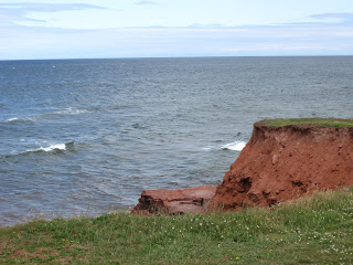
The most interesting things about PEI that I have noticed so far is the reddish copper colored beaches of the south side of the island.  The sediments that formed the rocks contained a large amount of iron. This iron over the years has oxidized, forming rust which makes it's sedimentary rocks red.  This is a picture I took at East Point, a spot where you can see Cape Breton in far away Nova Scotia in the distance:


When you walk on the beach, you come home with your foot red like it has been rusting.  

Sunday, November 6, 2011

Napoleon at Elba

My knowledge of 19th century European history is rudimentary at best.  For the longest time, I thought that Napoleon had spent the end of his days in exile on the island Elba.   While he did spend time exiled on Elba, it was for a short amount of time and before his defeat at Waterloo.  His end days were spent in exile on another, far more remote, island named St. Helena.

Napoleon went to Elba after his loss in the Battle of Leipzig in 1813 and abdicated from his title of Emperor of France.  Elba appears to be a beautiful place. If I were exiled, it would nice place to spend my time.  It is in the Mediterranean not too far from his native Corsica.   He lived in a villa, no prison cell.  He was given an escort of a 1000 men and the title of Emperor of Elba.  In the nine months he was there he formed an army and navy, he ruled over the 110,000 people, developed the iron mines and resided over the island's social calendar.

After he escaped from Elba, he returned to Paris and was greeted by the people with cheer and was reinstated as Emperor.  He then took up arms again and returned to the battlefield and met his biggest defeat at Waterloo in what is now Belgium.  When he was sent to exile this time, it was not a cushy exile.  No one wanted to ever see him again.  He was sent to St. Helena because it was the one of the most remote islands in the British Empire.   It was damp, windswept and mostly desolate.  He spent the last five or so years of his life depressed and sickly.

Tuesday, September 6, 2011

There Will Be No December 30th in Samoa This Year


The Independent State of Samoa is an island nation about halfway between New Zealand and Hawaii.  It is a short distance east of the International Date Line (the imaginary line that separates today from tomorrow).  In 1892 they agreed to be in this time zone so that they could on the same business day as their largest trading partner, the USA.  Before the invention of the telegraph, it wasn't very important to have a standard calendar with consistent time zones because people and data traveled so slowly.

On December 29th of this year, 2011, Samoa will be changing sides of the international date line.  The line will be redrawn so that they will be west of the line.  The change is due to the fact that they now do more business with Australia, China and New Zealand than they with the US.  They prefer to be on the same day as their strongest trading partners.  So after the change, they will be three hours ahead of Australia rather than 21 hours behind. Seems like a logical change from their point of view.  What makes this really interesting is that they will not have a December 30th this year.  At midnight on December 29th, they will be on December 31st.  So if you live on Samoa and your birthday is December 30th ... you are off the hook.

This isn't the first change they have made to realign themselves with Australia.  Back in 2009 they stopped driving on the right side of the road and changed to the left.  That must have a been a blast!   The changes for this were economic as well because it is much cheaper for them to import cars from Australia, with the driving column on the right, than to import from the US.

Sunday, August 21, 2011

Ponds, Lakes and Fjords


The first house my wife and I ever bought was near Monkton Pond in Monkton Vermont back in 2001. What is interesting about Monkton Pond is that it is sometimes a pond and sometimes a lake. It is my understanding that the difference between a pond and a lake is not the size of the body of water although most lakes are bigger. The difference is that a pond is fed by an underground source while a lake is overground. A good part of the year, Monkton Pond is fed by over ground source like streams but when the water is low, they don't exist. The name of the pond changes as well based on who you talk to. If you ask a local, the pond's name is Monkton Pond. If you ask a realtor, it is called Cedar Lake. Apparently, Cedar Lake sounds nicer on brochures and websites.

One of the great advantages of living in Vermont is that we live just a short drive away from one of the most vast and beautiful countries on the planet, Canada. You could say that the US is as beautiful as Canada but there are much fewer people in Canada. It makes it so much more accessible. Our national parks have traffic jams of RV's and campgrounds that are at capacity. While theirs have little traffic and many camp sites available to you. We honeymooned in Jasper National Park in Alberta in 1998 and were in a campground, "Wapiti," that must have been 90% empty. Why would anyone deal with the American RV traffic when the Canadian alternative is available?


Our latest trip to Canada was a road trip from our home, a six and half hour drive to the Saguenay, Quebec (same as our recent road trip to Philadelphia). If you look at a globe you can see how Quebec City and Montreal are connected by the St. Lawrence River. North of Quebec City the St. Lawrence widens becomes a seaway (aka a sound). It is basically salt water at this point. In 2002 we drove on the east side of the St. Lawrence seaway up to the Gaspe Pennisula where it reaches the Atlantic Ocean. We camped in Forillon National Park with a view of the Gulf of St. Lawrence. This year we drove up the west side of the seaway, not as far north and rented a cabin in Petit Saguenay. The attraction? the Fjord.

A fjord is a long, narrow inlet with steep cliffs along its sides that were carved by glacial activity. The picture I embedded was taken from one of the bays entering the fjord. I could not go any further with my kayak because the weather in the fjord is rough and unpredictable. I don't have a sea kayak either so I turned back because I don't have a death wish. The cliffs in this fjord get higher and steeper. They are spectacular.

The area where the fjord meets the seaway makes for excellent whale watching in late July and the month of August. We saw many minke and finn whales and possibly a blue whale. There are two blue whales in the region. We may have seen one in the distance, but the conditions were not clear enough to verify. It is also a good area to view beluga whales, but the weather conditions prevented us from seeing them. We did see a lot of grey seals. This picture is of a minke whale.


I have heard a number of Americans complain about Quebec saying the people there are rude. I cannot say this is my experience at all. I have been visiting Quebec since I was a kid and I haven't had any problems with rudeness or attitude. I do hate the way they drive up there, a driving style that makes Boston drivers seem sane and polite. Once they leave the confines of their cars, the Quebecois have been nothing but polite in my experience. I do not speak French well. I start each interaction with a polite "parlez vous Anglais" (do you speak English). The further north you go, the more likely the answer will be "non," but most service employees (waiters, hotel or tourism workers) are bi-lingual. To me, the challenge of the foreign language is all a part of the adventure.

Friday, December 17, 2010

The Kuril Islands

I sometimes forget how close Japan is to Russia. The only thing between the island of Hokkaido and the Kamchatka Peninsula is a line of Pacific Islands called the Kuril Islands. If you look at the map they look like stepping stones. This is probably why they have been the object of dispute between the two nations for a very long time.


In 1945, while Americans were settling into their post-war lives, the Soviet Union continued fighting taking the four most northern islands (Iturup, Kunashir, Shikotan and the Habomia rocks) from Japan. We tend to be Euro-centric in our study of world history. We only hear about the land grab that occurred in Eastern Europe, but this is the first time I ever heard of this. Technically, the peace treaty between the two nations was never signed. As part of the Yalta Agreement the USSR was promised the islands south of Kamchatka, but thanks to some ambiguous language and disagreement between some geographers, no one agreed which islands this meant. During the summer of 1945 USSR troops invaded and took the islands. Two years later, all Japanese residents of the island were expelled.

This are is still disputed. When President Medvedev visited the island in November of this year he was met with a slew of protesters. He even posted his pictures on Twitter and he made it clear on who he believe owned the islands here are some of his twitter postings:
  • "It's the president's duty to control the development of all Russian regions, including the remotest ones"
  • "How many beautiful places there are in Russia!"

Friday, November 6, 2009

The Flat Earth Society

I am a skeptic. Quite some time ago, I came to the realization that most people are not. I just deal with it. I tend to want more evidence than most people. When I don't understand something or when I find it unexplainable, I try not to cling to a popular idea or a simple explanation ... I usually need more evidence. I find it okay to say that "it is unknown ... at the moment."

Lately I have heard people on podcasts, radio shows and in person refer to things that I just don't believe exist. Of course, this is not new but it does seem to be happening more these days. They talk about ghosts or Sasquatch with such strong conviction and an assumptive air about them that I am taken aback. I am not sure if this is something I should point out to them or just shut up and accept the fact that they see the world differently than I do. I feel the same way when people assume that I believe in God, but on these occasions I don't hesitate to state that I am an atheist. In an era of political correctness, don't they have tolerate me as well?

Last week I heard someone refer to the Flat Earth Society. I thought this was a joke until I thought to look it up today on the net. There are actually people who still believe that the earth is flat, specifically, a flat bottomed disc with the North Pole at the center with a large sheet of ice surrounding the continents. Their view of the planet looks a lot like the flag of the UN. These are the same people who started the conspiracy theory that the Apollo landing was a hoax. Even Christopher Columbus believed the world was round. He thought he was in Asia instead of being on the "new" continent of North America, but even he knew he traveled around the planet.

I have to say that I am a little fascinated by their on-line forum. They were founded in 1956 by an English astronomer named Samuel Shelton. When he saw the first few satellite pictures of the Earth and claimed its shape was a dome and not a sphere. The Society officially disbanded in 2001 but they still have a presence ... you got it ... on the net. I hate posting the link for fear of spreading this nonsense, but I find myself too fascinated not to (kinda like attending a freak show).

My first thought on hearing about this is group that they were just another group that were not being skeptical enough. But perhaps the opposite is going on here. Perhaps they are being so skeptical that they are not accepting something that is just too obvious. Believing in a conspiracy of this magnitude is mind blowing.

Wednesday, December 31, 2008

Korea

Today is the last day of the year. With this posting I have met my goal of blogging more than I did last year. I do realize that I have cheated and that I have two entries today (on a blog called "What I Learned Today") ... but hey, it is my blog and to quote Cartman ... " I do what I want."

We have had a young person from Korea living with us since September and since then I have learned a lot about Korea. Before he moved in, what I knew about Korea came from the TV show M*A*S*H or from the Stephen Colbert song, "Singing in Korean". Sad, I know. So I have learned a lot just from talking with him and having a heighten sense of all things Korean. Every time the word Korea is said on NPR, my ears perk up.

For one, in Korea, the day you are born you are considered 1 year old. So I am actually 44 in Seoul but still 43 here. You get younger when you leave Korea and older when to go there.

Koreans don't really have middle names but generational names. Each family keeps a book for their family. You merge the middle name on the end of your first name, so if your first name is Chin and your generation name is Su then your name is Chinsu. All your siblings have the same generational name so if Chinsu has a brother named Dae, his full name would be Daesu.

Seoul is the largest city in South Korea, but Pusan (aka Busan) is the next largest. It is about the size of Chicago but with a warm climate on the southern tip of the country. Pusan was unscathed by the Korea War due to how far it was from the northern border.

Pusan's baseball team is called the Lotte Giants. The Korean Baseball Leagues has 8 teams. They have the name of a corporation and then the team name. Lotte is a huge conglomerate a lot like General Electric. Hundai, Samsung and LG all have teams as well. Their league has only existed since 1982 but is very popular and probably will grow. The champion of their league will face the Japanese, Taiwan and Chinese teams in the Asia World Series.

I get the impression that Koreans love American culture and products especially our beef. Their current president, Lee Myung-bak, lost favour with the voting public when he banned American beef due to fear of Mad Cow disease. His approval rating is lower than Bush's at 17% the last I heard. Coming to the US on vacation is not very practical due to the distance so Australia is a good substitute. Japan and Hong Kong are also popular, but China is not.

I have learned a lot by having a bright young person from another culture in my home. I recommend it to anyone interested in learning something new. Happy New Year.

Saturday, December 27, 2008

Kiribati and Global Warming refugees

The island nation of Kiribati's 94,000 or so residents have a problem. By the year 2100 their entire nation with be under water in the Pacific Ocean. Two of their islands, Tebua Tarawa and Abanuea, already disappeared in 1999. Coconuts will no longer grow on several of their islands due to the salination of the soil. Salination problem is expected to spread to the rest of the islands by 2050 and so goes their economy. These folks are becoming refugees of global warming ... or a term that we will probably start using a lot soon ... Global Warming Refugees or Climate Refugees.

Kiribati is on the equator and is the eastern most nation in the world. They are always the first to celebrate the New Year. It consists of 32 atolls and several island groups that are just a couple of feet, at it highest, above sea level. Their president Anote Tong has started thinking long term and has been helping his citizens relocate already. He has worked with getting his citizens residency in their neighboring countries of Japan, Australia and New Zealand. New Zealand has already agreed to accept 75 of them a year.

Wednesday, November 5, 2008

The Molotov–Ribbentrop Pact and the city of Danzig

The Molotov–Ribbentrop Pact is the short name of the non-aggression pact between Nazi Germany and the Soviet Union signed in August 1939. The longer, more official name is Treaty of Non-aggression between Germany and the Union of Soviet Socialist Republics. It was named after the two high ranking representatives from those nations, Soviet foreign minister Vyacheslav Molotov and German foreign minister Joachim von Ribbentrop. The term non-aggression on its own sounds nice until you understand that it just meant that they weren't going to be aggressive to each other while they invaded the nations around them. Barely a week later on September 1st, Germany invaded Poland on their eastern border while the Soviets waited until September 17th to invade them from the other side. They both went on to invade the nations of Finland, Estonia, Latvia, Lithuania and Romania splitting the land and resources into their respective spheres of influence. Only Finland was able to hold them off.

Under the Versailles Treaty after World War I, Poland was guaranteed access to the sea (the Baltic). So the city of Danzig was declared a free city under the auspice of the League of Nations. So this split Germany up with a small portion of the nation disconnected from the mainland (where Konigsberg is now). Not a good situation. The city had its own currency, stamps and national anthem. Germany wanted to build a highway connecting Konigsberg to the rest of Germany. When this did not happen, Germany demanded Danzig back. Poland, having recently signed the Anglo-Polish military alliance, pushed back believing that having England (and France) behind them, Germany wouldn't do anything about it. Hence, ... as it is said ... the rest is history.

Tuesday, July 17, 2007

Slovakia and Slovenia are two different countries

I was recently on a river cruise in Eastern Europe on the Danube River. The journey from Nuremburg, Germany to Budapest, Hungary was not only relaxing but intellectually fulfilling. We stopped at two other German cities (Regensburg and Passau) and three Austrian cities (Melk, Linz and Vienna). We passed by the capital of Slovakia, Bratislava but did not officially enter this nation. While on the boat watching this beautiful city go by us, conversation among the tourists ensued. Some were calling it Slovenia and some were calling it Slovakia. I said to someone that this was Slovakia, not Slovenia but I since I wasn't 100% sure that Slovenia was a different country and not just another name of Slovakia I didn't push the point.

Now that I have my internet access back, I double checked. Slovenia is a different country from Slovakia. Slovenia has a very long history, most recently it was once a part of Yugoslavia since 1945 and gained independence when that country broke up in 1991. It is east of Italy on the Adriatic Sea.

Slovakia became an independent nation recent also, when Czechoslovakia split up (often called the Velvet Divorce) into two distinct nations, the Czech Republic and Slovakia, in 1993.

It is easy to see how this mistake is made since all this history happened within two years of each other.